west
coast
tas

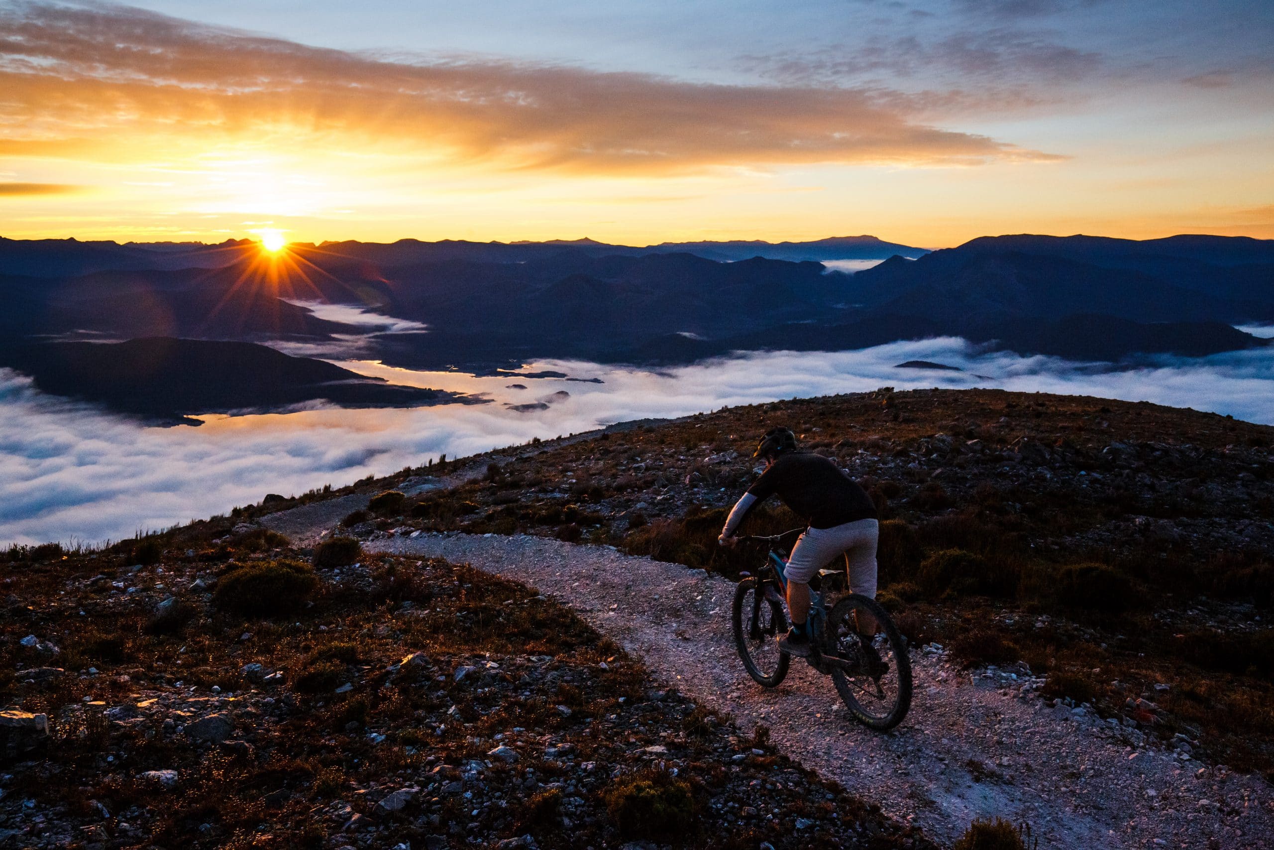
Wherever you go in Queenstown, Mt Owen looms large at an impressive 1,146 m above sea level. On a clear day from the top, gaze towards Frenchman’s Cap, ponder the lost towns lying under Lake Burbury or look West across the Southern Ocean.
Once heavily wooded, the area’s long industrial mining history and heavy timber felling left their mark. The mountain now lays bare its dramatic ridgelines and geology, making this trail network a unique and highly engaging riding experience.
Book a shuttle to experience the Upper Mountain trails or get on your bike and pedal the unique landscapes of Lower Mountain to earn the views.
These trails are in remote and exposed mountainous areas subject to sudden and extreme weather changes. Please ensure you are adequately experienced, prepared and equipped to complete these trails. You ride these trails at your own risk, ensure you have checked the weather forecast and packed enough food and water
Upper Mountain
These trails are remote and physically demanding. Intermediate or above skill level recommended.
All of the Upper Mountain trails are accessed by a shuttle service out of Queenstown. Pre-booking a shuttle prior to your arrival in Queenstown is highly recommended. Throughout the winter months, shuttles have a limited timetable and need to factor in the season’s shorter daylight hours.
Lower Mountain
Accessed via a short ride from town to Tramway St, you will find trails to suit all skill levels. Feature-packed trail riding and awesome views await.
Read Less -
Waterfall takes riders on an epic backcountry journey, filled with waterfalls, boulder fields and rugged terrain. Riders will pass by the top of Horsetail Falls before plunging into a remote valley. An iconic descent with a range of trail features. Links on to the Welcome to Queenstown descent.
A taste of big mountain adventure along precipitous ridgelines linking Mt Owen to the North Owen peak. Steep chutes, technical flow and a short climb will get you primed to drop into the valley below. Try and keep your eyes on the trail as Frenchman’s Cap to the east and Lake Burbury 700m below vie for your attention.
Go above and beyond. Departing from the Chamouni Traverse, this back-country style trail provides an alpine, big mountain experience that is entirely uniquely West Coast. Climbing to the peak of North Owen, perched high up at the head of the Chamouni Valley, riders can experience a truly rugged, remote and technical riding experience before either returning back around to The Long Spur or committing to the North Owen Descent.
From Chamouni Traverse and the shoulder of the North Owen Peak, this rocky ridgeline is remote, rugged and exposed. The trail weaves down the top of the ridge all the way to the valley floor, offering riders an engaging mix of berms, rocks, gravel and expansive views up the valley to the historic Mt Lyell mine and once-bustling townships of Linda and Gormanston.
This exposed, steep and demanding trail follows an improbable ridgeline from the North Owen peak directly to the valley floor below. An unrelenting descent for experienced riders only.
Beginning with a hike/ride (approx. 20 mins) up to the trailhead above 1000m on Mt Owen, the trail traverses highly technical terrain before it gains the prominent summit ridgeline. The descent that follows is a raw, technical riding experience unlike anything else in Australia. For highly experienced riders only. Links onto ‘Waterfall’ near Horsetail Falls.
A gentle two-way linking trail along Conglomerate Creek at the bottom of the Little Owen trails. A nice place to head on a hot summers day.
A great first taste of mountain biking in Queenstown, or the perfect shorter loop for any rider. Ready or not, you’ll have to ride uphill to get all the fun on the way back down!
A loop trail taking riders further up onto Little Owen, the trail continues climbing from Ready Orr Not. With dramatic 360 degree views and plenty of giant berms and rollers, this is a trail not to be missed! Be sure to wave to the cars on the 99 bends before you drop into the descent back down to Conglomerate Creek. This trail is sure to make any rider smile.
Continue upward and into the hills from Welcome to Queenstown. After a short, sharp climb you are rewarded by some of the best views in the trail network and a wide range of optional more challenging technical trail features.
A remote, backcountry style trail through a truly unique landscape. The trail follows part of a historic track that once linked the towns of Lynchford and Gormanston in the late 1800s.
The Mt Owen trails are waiting for you, plan your ride by downloading the map via the button below.
Please note: These trails are in remote and exposed mountainous areas subject to sudden and extreme weather changes. Please ensure you are adequately experienced, prepared and equipped to complete these trails. You ride these trails at your own risk, ensure you have checked the weather forecast and packed enough food and water.